Roman Aqueducts
This article was initially written by Robert Woods, ASME Fellow. This article contains material published in Mechanical Engineering Magazine Sept. 2003. Copyright 2003 American Society of Mechanical Engineers
At first glance, the most strikng feature of a Roman aqueuct is the mathematical precision of the arches. These structures are beautiful, and the Romans have written about their beauty, but aesthetics were only secondary. Aqueducts were built for a utilitarian purpose. They supplied the water that is the lifeblood of any civilization.
Without an abundant source, Rome, which in its prime in antiquity was a city of somewhere between a half-million and a million, could not have existed. These structures were too important to be the work of amateurs. Rome had a very professional corps of engineers who made a lasting contribution to Western civilization by building them.
The place of engineering in history can be judged by the traditional date for the beginning of the Dark Ages, March 537, when the king of the Ostrogoths cut the last aqueduct supplying water to Rome and proved conclusively that the Western empire was finished.
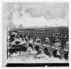
Pont du Gard, the aqueduct spanning the Gardon River north of Nimes, France, is one of the best surviving examples of Roman aqueduct construction. It transported water from a spring 20 km from the city center and only 14.6 meters above the point of delivery. In a straight line, this would have been a slope of a yard and a half per mile, but the route was far from straight. Because of the circuitous route, the channel's actual length was more than 50 km.
A 21st-century engineer can't help but ask, how did they do it? The structure was built 2,000 years before GPS or laser surveying equipment. It had long been thought that particular aqueduct was built around 20 B.C., probably by Marcus Vipsanius Agrippa, who also built the Pantheon and other structures in Rome. He worked upon direct orders from Caesar Augustus and was, in fact, Augustus's top aide in areas other than architecture. Later studies now date it to about 50 A.D. and attribute it to an unknown architect.
If we study these structures, we find that the Roman understanding of hydraulics was well advanced. We also find that surveying and construction depended on the primitive-not to be mistaken for crude-process of breaking every geometric problem into a series of orthogonal blocks of manageable human size and repeating the process as many times as needed to cover the horizontal and vertical extent of the terrain. This applied to site surveying as well as to the lofting of the structure.
Zero and 90-degree angles are fairly easy to lay out. Anything in between is another problem. The precise measurement of angles other than right angles was rarely done and, in the absence of trigonometry, would have been pointless.
This breaking of the problem into rectangles- or prisms in the three-dimensional case-can be thought of as mesh generation on a geological scale. Hero of Alexandria, around the first century A.D., wrote a series of Treatises on this subject. The steps by which he reduces the geometry of an irregular landscape to a series of orthogonal constructions look familiar to those of us who worked infinite element analysis during the days when we were hard put to program a computer to generate anything other than a square mesh.
The greatest part of our knowledge regarding Roman surveying instruments-along with information about a wealth of other ancient technology-comes from the writings of Marcus Vitruvius Pollio in the first century B.C. Among other topics, he discussed surveying in his 10 surviving books on architecture.
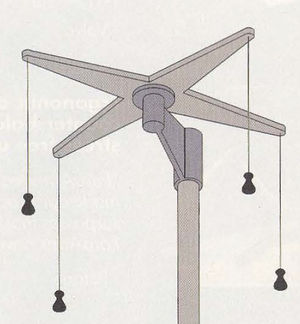
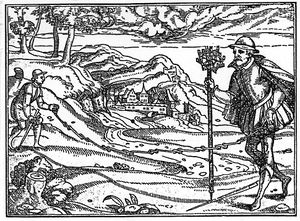
Plane mapping was accomplished with orthogonal grids that were laid out using an instrument that resembled a Tibetan prayer wheel. In that device, called a groma, a cross-shaped frame was mounted horizontally on a vertical column. At each end of the cross, a plumb bob was hung. Right angles were constructed by sighting along orthogonal pairs of wires.
Although it was the workhorse of Roman surveying, this arrangement was not easy to use in the field. Vitruvius emphasized that it was particularly difficult in any appreciable wind. The presence of a breeze called for various expedients, such as constructing tentlike screens around the instrument or the more sophisticated approach of dampening the swing of the bobs by suspending them in containers of liquid.
Maps were created using rectangles whose sizes were limited by the topography of the region, since it was necessary to sight visually, and with the unaided eye, along the edge of each rectangle.
Since nothing resembling the precision of modern theodolites existed, elevations were determined by an arrangement that was even more cumbersome than plane surveying. A choice of several instruments existed, but whichever was used, vertical offse ts were determined, not by measuring angles, but by establishing a horizontal reference at some point and sighting from that point to a measuring rod held vertically at the next survey point. This was repeated inchworm fashion as many times as necessary to reach the final elevation.
These measurements might then be tied to a planar surveying that had been done as a preliminary. The distance between each pair of points was limited by the practical length of a measuring rod and the need to maintain an unobstructed line of sight.
M.J.T. Lewis has published a work that is a dazzling combination of classical scholarship and pragmatic experimentation, Surveying Instruments of Greece and Rome (Cambridge University Press, 2001). Among other things, he has undertaken a comprehensive study of the limits of accuracy that are attainable using modern reconstructions of ancient instruments.
According to Lewis, it appears that in most cases the horizontal reference was established using an instrument called a dioptra, which was a suspended vertical sector fitted with an alidade and leveled by fore and back sighting. Another instrument, called a libra because of its resemblance to a scale, was also used.
In some cases, a clumsy arrangement called a chorobates was used. Lewis, a retired lecturer in industrial archaeology at the University of Hull in England, speculates that the credit given to this instrument by Vitruvius was out of proportion to its real usefulness. The chorobates was an elongated wooden platform, sometimes with a water-filled longitudinal groove, having plumb bobs on each end that were aligned with fiducial marks on the structure. These were used to level it to the horizontal.
Sighting at a far point was done along an optical path grazing the platform's surface. If the surveyer did it properly, the target point would be at the same elevation as the surface of the chorobates. In some cases, the groove was filled with water and the same process performed, sighting above the water level at each end of the instrument. This application is described in detail by Vitruvius.
The Roman practice of reducing a problem of irregular shapes to a series of manageable- sized orthogonal blocks may have been primitive, but it got remarkable results. The Romans could lay out structures successfully, as in the case of the Pont du Gard, with slopes of one part in over 4,000. Although a little luck may have been involved, that was impressive even by modern standards. That it was done with instruments as primitive as plumb lines and water levels is amazing.
The recent interest in applying modern analytic and experimental techniques to the study of ancient engineering has inspired a good deal of research. Hubert Chanson, a reader in the Department of Civil Engineering at the University of Queensland in Australia, has published several papers on the subject and has mounted an introductory Web site, "Some Hydraulics of Roman Aqueducts." The site gives numerous references to other literature, including experimental work by himself and V. Valenti in 1995.
Their conclusions demonstrate that the Roman hydrodynamicists, although working without the benefit of modern analytic techniques, were surprisingly sophisticated in their handling of large flow volumes and-sometimes-large hydrostatic heads. When it came to distributing water to end users, their work was less satisfactory.
After being conveyed cross-country by aqueduct, water was distributed to consumers in two ·vvays. The more common was public fountains, often very elaborate, which were social centers visited by the general populace bearing water jugs. Wealthier citizens and businesses had water delivered directly to their sites by a system of pipes and valves that closely resembled their modern counterparts.
The piping, typically lead, was remarkably durable. Functioning examples still exist after 2,000 years. Water was rationed to each user by calibrated orifices scaled to a user's annual fee. The engineering was, in fact, rather naive compared to the sophistication of the aqueducts themselves.
The flow rates of the orifices were poorly related to their cost. A bewildering assortment of standard orifices existed. These orifices were documented in great detail by Sextus Julius Frontinus when he was appointed, in the first century of our era, to the very responsible position of water commissioner.
If you care to brush up your Latin, his work is available in a 1969 edition, with an English translation by C.E. Bennett on one page and Latin on the other. Frontinus appears to have been a compulsive writer. He documented the aqueducts and their ancillaries in meticulous detail - in contrast to the casual attitude of the many bureaucrats who previously held his position.
In his writing on the aqueducts, he actually published as much on military tactics he gives the dimensions of 25 selected orifices along with speculation as to how the odd sizes came to exist. Although he devotes great attention to the question of diameter versus area, the length of the tap, which we know to be vital to discharge rate, is treated rather naively.
It doesn't appear that the characteristics of the taps were investigated with what we would now regard as scientific rigor, but then the Romans did not have two millennia during which the scientific approach evolved. In contrast to their science, their understanding of human nature left little room for criticism. We see this in Roman laws, many of which have been handed down to us unchanged.
The Romans understood that there will always be people who try to beat the system. Frontinus devoted much attention to discussing the devious means by which culprits helped themselves to more of the public water supply than they were entitled to. This sometimes took the form of concealed illegal taps, but the system could also be defeated by oversizing otherwise legal installations.
An effort was made to control such abuses using an approach we echo, two millennia later, in ASME Code stamps. Taps were stamped with their size by authorized inspectors. An unmarked tap could be immediately seen as illegal and deputies were held personally responsible for guaranteeing the dimensions of taps that had their stamp.
This was an example of the same Roman quest for perfection that would not permit them to tolerate inaccuracies in the arches so characteristic of their architecture. It is no coincidence that the man who was water commissioner also wrote a book on military tactics. This same instinct for precision gave Rome an army whose strict discipline, unique for armies of the time, made it master of the Western world.


