The Global Positioning System or GPS is a great technological success story. Developed in the 1970s and 1980s by the U.S Department of Defense (DoD), the system was primarily intended for the U.S military. It was successfully used in the U.S-Iraq War (1990-1991) and U.S interventions in Kosovo (1999) and Afghanistan (2001-2002). Non-military use was a secondary objective, and throughout the 1990s civil users were limited to a purposefully degraded subset of the signals broadcast by GPS. Despite these limitations, civil applications of GPS grew at an astonishing rate. Applications unforeseen by the designers of the system are now thriving, and many more are on the way. Through applications in land transportation, civil aviation, maritime commerce, surveying and mapping, construction, mining, agriculture, earth science, electric power systems, telecommunications, and outdoor recreational activities, GPS is well on its way to becoming an essential part of the commercial and public infrastructure.
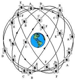
The baseline the GPS constellation comprises 24 satellites arranged in six orbital planes (lettered A-F). Each plane is inclined at 55° from the equatorial plane. The orbital period is 12 hours.
The principle of satellite navigation is very simple: your position can be determined if you can measure your distance from each of three objects whose positions (i.e., coordinates in a well-defined reference frame) are known to you. In order to implement a global navigation system based on this principle, GPS has fielded a constellation of 24 satellites in medium-earth orbits with a 12-hour orbital period. These satellites are the objects at known locations from which a GPS receiver measures ranges. Actually, the satellites are moving in space at a speed of about 4 kilometers (about 2.5 miles) per second, but the position of each at any instant can be estimated from its broadcast message with an error no worse than a few meters. The distance between the user and a satellite is measured in terms of the time it takes a radio signal to travel from the satellite to the user. Precise measurement of transit time is accomplished by transmitting signals with precision in accordance with nearly perfectly synchronized clocks carried aboard the satellites.
In order to measure the true transit time of a signal from a satellite to a receiver, it is critical that the clocks in the satellite and the receiver be in synchronism (that is “in sync”). Fortunately, this tough requirement is easily sidestepped, allowing use of inexpensive quartz oscillators in GPS receivers. The bias in the receiver clock, (that is, the amount by which the receiver clock is out of sync), at the instant of the measurements affects the transit times for all satellites equally. The corresponding measured ranges are thus all too short (or too long) by a common amount. These biased ranges are called pseudoranges. The receiver clock bias thus becomes the fourth unknown to be estimated, in addition to the three coordinates of position. A user, therefore, needs a minimum of four satellites in view to estimate his four-dimensional position: three coordinates of spatial position, plus time.
With GPS, you can determine your three-dimensional position instantaneously, continuously, and globally with an accuracy of several meters. Thanks to precise and ultra-stable clocks carried aboard the satellites, an inexpensive GPS receiver can also serve as a precise clock, keeping time with an accuracy of about 0.1 microsecond (that’s a tenth of one millionth of a second!). In fact, GPS has become a true global time reference for commercial and scientific activities. GPS users the world over have become accustomed to such accuracy in specifying position and time. The only requirement is for the receiver antenna to have a halfway clear view of the sky to be able to “see” a minimum of four satellites.
The GPS signals are extraordinarily faint and may be so attenuated in propagation (that is, weakened) through foliage that it becomes difficult for a hiker to navigate in the woods. Indoors, the signals are far too weak to be tracked independently. But GPS will provide position and time indoors in the near future with a little assistance from terrestrial radio signals transmitted specifically for this purpose.
Further References
Hugo Fruehauf Oral History, IEEE History Center, 2020
Brad Parkinson Oral History, IEEE History Center, 1999.
Richard Schwartz Oral History, IEEE History Center, 2020
James Spilker Oral History, IEEE History Center, 2019
Build it and They will come: the Far-reaching Effects of Global Positioning Systems.
Arthur Stern Oral History: Satellite Navigation to Shipping Companies, IEEE History Center, 1993.


